|
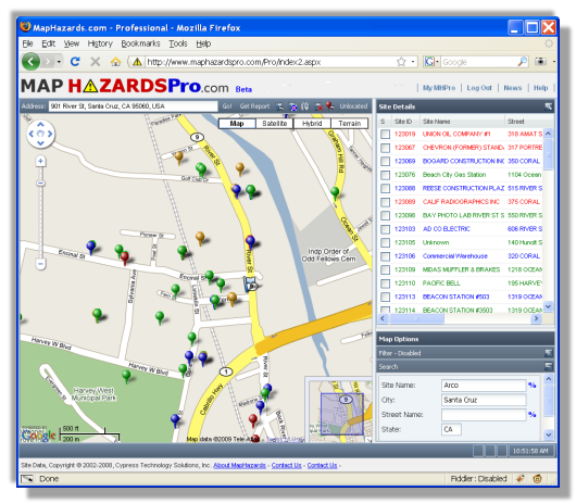
MapHazards Pro is the first and only service that lets an environmental professional, regulatory
agency or anyone else see ALL of the environmental hazard sites - national, state and local -
in one place with a powerful, but easy to use interface.
This service is a game changer. Every Leaking Underground Storage Tank, every Brownfield,
every Superfund site is here for you to see.
We do not just show you some point on a map. We also back it up with complete details from the
regulatory agency databases.
For instance, want to see all LUST sites on 10th street in Minneapolis? Just type in that search criteria and their they are, on the map and in the list. You can search for all Engineering Controls in San Jose, CA, or see if that Shell station on Liberty St. is a LUST.
See our About The MapHazards Pro Map Research page for more information.
|
|
We provide industry standard ASTM 1527-13 database reports which are actually easy to use
and understand.
Our reports are very easy to order and are complete and available within minutes. They are organized
by both distance and database type to make them very easy to use for your analysis.
Our reports are used by major national and regional banks so you know you are getting a
trusted report.
Another advantage to our reports is their customizeablilty. We can make your report look the way you
need it to look, with the pages you need in the order you want. We can include your logo, put
the report on your letterhead, the options are almost unlimited.
And of course the data is top notch. The principals at the company have been doing this since 1994
so we know a thing or two about it!
See our About The MapHazards Pro Radius Report page for more information.
|
|
Our environmental data is the core of what we do and we have developed sophisticated software
and systems for acquiring hundreds of lists from hundreds of sources in hundreds of different
formats and transforming it all into a massive database without losing any of the unique character
of the individual lists.
And then doing it again in 3 months to keep it up to date!
If you need access to such a database, in whole or in part, for your product or project, drop
us a line and we can structure a licensing agreement that meets your unique needs.
Some examples of possible uses:
- A consumer level environmental report system for Natural Hazards Disclosure companies.
- As an additional layer in your in-house GIS system.
- The data source for a system to calculate environmental risk actuary tables.
- Emergency response planning.
- Environmental Impact Reports.
|